


Part 3 - Jun. 11th - Day 13 - The Surge Narrows - Sea kayak Vancouver Island Circumnavigation
- Felipe Behrens
- Mar 5, 2023
- 10 min read
Updated: Jan 30, 2024

I have noticed that there are a lot of place names here in the Pacific Northwest that have Spanish origin. Cortez island, Juan de Fuca Strait, San Juan Islands, Laredo Sound, Port Angeles, and many others. I asked Rebecca, the front desk lady, if she knew why.
“Well, you know, the Spanish were the first Europeans to sail through here in the fifteen hundreds. So, it would make sense they put their names on a few islands and capes, that’s what everyone did at the time. Then later came the British and they were always feuding with the Spanish over who was going to own what, so they put their names on top of the Spanish names, but sometimes the Spanish name just stuck. In fact, Quadra Island as you might have guessed is named after a Spanish Captain. His full name was Juan Francisco de la Bodega y Quadra, quite the mouthful. He was a friend of George Vancouver, yes, that Vancouver.”
“Oh really, and how do you know that?"
“Well, funny, no one’s asked me that. I actually learned it from a statue on the harbor in Victoria next to the Parliament Building. It says they had a chance encounter in Nootka on the west coast, which was a Spanish settlement, and because they didn’t immediately kill each other, which was the custom back then between the Spanish and the British, one of them said to the other, “hey, since we are friends, why don’t we name the whole island after ourselves. Let’s call it Quadra and Vancouver’s Island.
“But then of course, the British eventually kicked the Spanish out, and it became Vancouver and Quadra’s Island, because yeah, your guy’s name goes first, and because that was too long it became just Vancouver Island.”
“Haha, I guess that Vancouver must have spoken from the grave, “Hey, he was a friend of mine. Can he at least get a consolation prize? And so, that’s how he got Quadra Island named after him?”
“Ha, that would make sense, eh. He didn’t come out too badly, there’s a Bodega Point, a Francisco Island, and Sonora Island is named after one of his ships. Juan de Fuca, however, is a different Juan but I don’t know which one, there are too many different Juans.”
We talked for another half hour including what I should buy at the supermarket. “You like Chef Boyardee? Yeah, they have that there but it’s so gross! Who eats pasta from a can? Then again, you are paddling around the whole island, I guess you know what works better than me.”
I asked if I could stay one more day. She checked the availability, and said the room was free for one more night but I had to be gone the next day because a group of Chinese tourists on a tour had the entire hotel booked.
North of Heriot Bay the tides have some quirks. Up until now the flooding tide came from the south, barreling down the Juan the Fuca Strait before turning north and meandering through the San Juan islands and filling up the Strait of Georgia like a giant bathtub. But north of Heriot bay the reverse happens. The flooding tide starts from the north wrapping around Cape Scott, down through the Johnstone Strait and then into the northern sounds like an artery pushing blood through the circulatory system.
The water is also surprisingly warm here, especially around Heriot Bay. I made some rolls in the marina, and my first reaction was, “hmmm, I don’t feel the ice cream brain chills.” I took my gloves off, dipped my hands in the water, and it did not feel cold at all. Surely, it wasn’t the jacuzzi-like conditions of the seas around Miami that I am accustomed to, but warm enough that on a sunny day, I wouldn’t have minded going for a swim. I think that the reason the water is so much warmer here is because the tide probably doesn’t ebb for long enough to get mixed with the Pacific Ocean. The water just slushes back and forth in the strait, and with the long days of the summer, it steadily accumulates heat. The winters must also consequently be much colder here than anywhere else in British Columbia.
There are two pathways north from Heriot Bay The main path runs between Quadra and Vancouver Island and is called the Discovery Passage (named after the Discovery which was the ship captained by George Vancouver), and it begins on the southern tip of Quadra Island in a place called Cape Mudge where a lighthouse marks the entrance to the passage. From there Quadra Island progressively hugs ever closer to the Vancouver mainland, and the channel becomes ever narrower over a stretch of about thirteen miles. From my work as an engineer, I know that fact speeds up the water because of the venturi effect (there is a flow meter called the venturi meter which calculates the flow by measuring the drop in pressure in the pipe before and after an induced constriction). Water is an incompressible liquid and so the only way to pass the same amount of fluid through an increasingly narrower opening is for the flow velocity to increase. The throat of the passage, called the Seymour Narrows lies just north of Campbell River. My friend Lee told me harrowing stories about this place.
“At peak flow, the Seymour Narrows are like a horizontal waterfall. You’ll see white foam everywhere, the ferries get tossed around like rubber ducks in a bathtub, and the whirlpools swirl like galaxies. I think that something like a hundred ships have sunk there over the years until the Ripple Rock Explosion.”
“What was that?” I asked.
“Oh, it’s a famous event here in Canada. Ripple Rock was a shallow underwater rock right on the mouth of the Seymour Narrows; it created the biggest standing wave in the world. When the current was ebbing half the channel was a mini–Niagara Fall, and when it was flooding it made a gigantic upwell. You could only sail up or down the passage at slack tide. Boat traffic piled up on either side waiting for the brief ten-minute window twice a day.
Anyone too impatient risked getting smashed on the rocks.”
“And so, they blew up the rock?”
“Yes, that’s right. In 1958 the Canadian government decided they would get rid of the rock by blowing it up. They had to drill an underwater tunnel to get under the dome of Ripple Rock, filled up the tunnel with a ton of explosives like the Coyote and the Roadrunner, and then blew it all up. You ask anyone here in BC, and they will tell you it’s the biggest non-nuclear explosion in the world, ever.”
“So, can you paddle through there now?”
“I’ve heard of people paddling through the passage. It’s still very treacherous, and you have to wait for the slack tide at Maud Island on the mouth of the narrows; a big powerful motorboat can handle the current, but I certainly wouldn’t do it on a kayak loaded with gear; especially with all the boat traffic.”
I ruled out paddling through the Seymour Narrows.
The other path north is through the Surge Narrows and the Okisollo Channel which run along the opposite side of Quadra Island and is a finger of the Johnstone Strait and the Discovery Passage. The current there is not quite as ominous as the Seymour Narrows, but peak flow easily gets above ten knots, and any kayaker will have a very tough time making it through the throat of the narrows.
I had been to the Surge Narrows once before. In November the previous year, Lee ran a five-day kayak surfing course, which I attended to hone my skills. At the mouth of the narrows are three small islands and countless islets that spread into a maze of channels, standing waves and eddies.
During the course I paddled a P&H Delphin 150 which is a surf sea kayak made for sharp turns and quick edge responses. Still, I cannot say that I showed particularly great handling skills in this type of condition. Somewhat counterintuitively, when you’re a standing wave, you know you’re doing everything right when you don’t have to do anything; you stay exactly in place, “falling down the wave,” at the same rate it rises underneath you. That sweet spot, however, is like holding your balance at the point of a knife and any small disturbance unless quickly counterted will be quickly amplified and you will be thrown off the waves like a cowboy riding a bull.
My current kayak, the Taran, is three feet longer than the Delphin and three inches narrower. It is made for surfing the ocean swells and definitely won’t turn on a dime, especially in the fast-changing water. Because of that I decided it would be prudent to make a day trip to the Narrows and get a feel for the conditions.
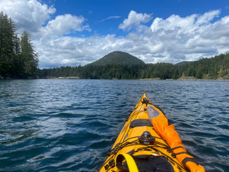
I dressed in my dry suit, put the boat on the water and began paddling ten miles north to the mouth of the narrows.
I immediately was surprised by how much faster and responsive the boat became without all the weight of the gear.
“Holy moly! I must be He-Man! I have the Power! Look how fast I can make this thing go!” I said out loud to the fish.
I paddled past the Discovery Lodge where Lee and I had stayed during our previous visit and arrived at the Surge Narrows close to the peak of the flooding tide (flowing from north to south). I hugged the shore near Quadra Island taking advantage of the back eddies to help me along, and eventually reached the mouth of the Narrows where a set of rapids separate Peck and Quadra Island. Several islets punctuate the rapids and create many back eddies where you can park your kayak and watch the current tumble down like a roll of toilet paper unfurling.
The largest of these islets is right next to Peck Island and the shadow of the islet makes a large back eddy with a pathway almost all the way up to the top of the narrows. If you are a super strong paddler, and can release a powerful burst of energy like a cycling sprinter in the Tour de France, maybe you can overcome the current and make it past the tipping point break free from the current, and delight yourself at the sudden calmness upstream of the rapids (if you are a hydraulic engineer you will know this is the critical point where the flow changes from subcritical to supercritical). If you don’t have the muscle, the current will carry you down and the smooth face of the water until it suddenly changes into a thrashing washing machine (there’s a technical term for this condition too, it’s called a hydraulic jump and is where flow changes back from supercritical to subcritical. You can see a hydraulic jump in all kinds of places. When you open the faucet sink and the water splashes like a disk, or when the smoke from a burning cigarette rises up in a smooth silky thread before decaying into a messy tangle. My university hydraulics professor noted that demonstration of a hydraulic jump was the only valid excuse to smoke in class, which he promptly did.Anyways, let’s not get sidetracked, back to the story.)
I paddled up the back eddy next to Peck Island. At the end of the eddy, I took a five-minute break and observed the current rushing by. It must have been about eight knots. I took three back strokes to position myself with a little bit of runway to accelerate, pointed the kayak at about seventy degrees to the direction of the flow, and then pressed ahead with all the vigor I could muster.
I did not pause to appreciate the sudden rush the kayak experiences when it enters the current and the water speed decelerates from maximum to almost zero and I continued putting in the strokes as furiously as I could like an Energizer Bunny. After about five seconds, I dropped into the trough of the standing wave into the sweet spot where the kayak is in freefall. I stopped paddling and admired the kayak being perfectly still as the clear water rushed by on either side, and the rocks just below twinkled like stars.
Sadly I must have lasted little more than five seconds. I put in a few corrective strokes but eventually overcorrected to the left and soon lost control of the waves and was carried downstream.
“Not too bad for an 18-foot-long boat.” I thought. “Let’s try again.”
I attempted five more times, but none went quite as well as the first, most likely because I was starting to run out of steam. On my last try the current grabbed tossed sideways into the hydraulic jump and flipped over. Thankfully, I was wearing nose plugs and decided to lay upside-down for a while until the thrashing had calmed down before rolling back up. I was surprised to see that I had drifted more than a hundred feet downstream of the rapids. That was enough standing wave surfing practice for one day. Instead I practiced zigzagging on the current by jumping in and out of the eddies while ferrying from one side of the channel to the other; this was a little more relaxing.
Please Consider Buying an Item to Help me Keep the Site Funded


I paddled to the east of the Surge Narrows past the channels between Peck Island, Sturt Island and Goepel Island. East of Goepel Island is Maurelle Island, and the widest part of the Surge Narrows. The water is flat, and the current is a little slower. I hugged along the shore of Maurelle island to get upstream of the narrows to a place I remembered had a large waterfall that tumbled into the sea. You could paddle underneath the falls and get a freshwater soak. I found the waterfall, it was rushing down like a firehose, but the tide wasn’t high enough to paddle all the way in.
By now it was close to midafternoon. I pulled out the tide and current tables that Marla had given me the day before, and checked when the turn would be. “two and a half more hours,” which I noted was about thirty minutes after the official peak high tide (slack high tide). After the turn I’d be paddling back against the flow, and so decided to start heading back to Heriot Bay.
But from my current location I had to continue paddling up the channel against the current hugging the shore along Maurelle Island until I would be directly upstream of the narrows between Peck and Quadra Island and could ride the current through the narrows. Unfortunately I turned south a bit too early which resulted in the most strenuous ferry crossing I have ever done.
Ferrying across a channel or river with strong currents is a delicate exercise in vector addition, how much of your energy do you devote towards fighting the current, versus crossing the gap. If you go straight across you will cross more quickly but at the expense of drifting down with the current perhaps so far that you never make it to the destination. If you point straight at the current you might be able to hold your position, but you will never make it across.
In my current predicament, nearly all my effort went into fighting the current with only a miniscule portion towards actually crossing the thousand foot wide channel. About three quarters of the way I noticed a back eddie closer to the opposite shore and allowed myself to drift with the current in exchange finishing the crossing. At the pace I was paddling I wasn’t going to last much longer.
Once I made it across, the eddy carried me along the backside of Peck island, and once I plunged into the current of the Surge Narrows, I could then ride effortlessly with the flow. Nonetheless, I still had to paddle another nine miles back to Heriot Bay, and the weather was promising a rough downpour. At least I had no gear to carry with me.
Sea kayak Vancouver Island Circumnavigation


Comments